
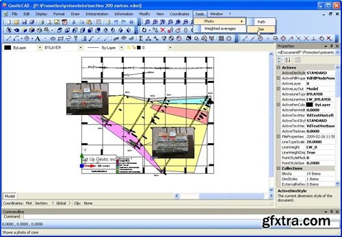
GeoticCAD application is designed to interpret and add the finishing touches to section drawings created by GeoticSection
• User-friendly and intuitive environment under Windows (XP to Windows 7)
• Trilingual (English, French, Spanish)
• Optimized to use sections drawings in the GeoticGraph VDCL 3D format
• Insertion of legends, graphic scales, and wind rose
• Simple movement between the 3 coordinate systems (World, Measure and Plot)
• Export to image format
• Export to PDF format respecting a sacle
• Export to DWG and DGN formats (AutoCAD and Micro Station software are not required)
• Automatic interpretation of the topography and the bedrock
System Requirements:
• Microsoft Windows XP, Windows Vista, or Windows 7
• 1 GB RAM minimum ~ Recommended: 2.0 GB or more
• Display dimensions of 1024x768 or greater

126,000 Royalty-Free 3D Model

Udemy Türkçe


Top Rated News
- CreativeLive Tutorial Collections
- Fasttracktutorials Course
- Chaos Cosmos Library
- MRMockup - Mockup Bundle
- Finding North Photography
- Sean Archer
- John Gress Photography
- Motion Science
- AwTeaches
- Learn Squared
- PhotoWhoa
- Houdini-Course
- Photigy
- August Dering Photography
- StudioGuti
- Creatoom
- Creature Art Teacher
- Creator Foundry
- Patreon Collections
- Udemy - Turkce
- BigFilms
- Jerry Ghionis
- ACIDBITE
- BigMediumSmall
- Globe Plants
- Unleashed Education
- The School of Photography
- Visual Education
- LeartesStudios - Cosmos
- Fxphd
- All Veer Fancy Collection!
- All OJO Images
- All ZZVe Vectors
- CGTrader 1 CGTrader 2