Video: .mp4 (1280x720, 30 fps(r)) | Audio: aac, 44100 Hz, 2ch | Size: 2.68 GB
Genre: eLearning Video | Duration: 31 lectures (4 hour, 32 mins) | Language: English
Become Expert in Geospatial analysis & Remote Sensing for machine learning in land use/land cover in Google Earth Engine
What you'll learn Homepage: https://www.udemy.com/course/google-earth-engine-machine-learning-geospatial-analysis/
Students will gain access to and a thorough knowledge of the Google Earth Engine platform
Implement machine learning algorithms on geospatial (satellite images) data in Earth Engine for LULC mapping
Get introduced and advance javascript skills on Google Earth Engine platform
Fully understand the main types of Machine Learning (supervised and unsupervised learning)
Learn how to apply supervised and unsupervised Machine Learning algorithms in Google Earth Engine
Learn how to obtain satellite data, apply image preprocessing, create training and validation data in Google Earth Engine
Implement calculation of change detection (pre and post-event detection) based on spectral indices
You'll have a copy of the codes used in the course for your reference
Requirements
A working computer with internet connection
An interest in working with geospatial data
Description
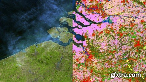
Land Use/Land Cover mapping and change detection with Machine Learning in Google Earth Engine
This course is designed to take users who use GIS for basic geospatial data/GIS/Remote Sensing analysis to perform more advanced geospatial analysis tasks using a variety of different data and applying Machine Learning state of the art algorithms. In addition to improving your skills in javascript, this course will make you proficient in Google Earth Engine for land use and land cover (LULC) mapping and change detection. As a result, you will be introduced to the exciting capabilities of Google Earth Engine which is a global leader for cloud computing in Geosciences!
I'm very excited that you found my Google Earth En gine course. This course is designed to equip you with the practical knowledge of unsupervised and supervised classification strategies for Land Use and Land Cover (LULC) mapping, which is one of the core skills for any Geographic Information Systems (GIS) and Remote Sensing analyst. By the end of the course, you will feel confident and completely understand and apply advanced Geospatial analysis including performing Machine Learning algorithms for land use and land cover mapping and spectral indices calculation and change detection. All this you will be able to carry out on the real (and open) data in Google Earth Engine.
This course is different from other training resources. Each lecture seeks to enhance your GIS and Remote Sensing skills in a demonstrable and easy-to-follow manner and provide you with practically implementable solutions. You’ll be able to start analyzing spatial data for your own projects, and gain appreciation from your future employers with your advances GIS skills and knowledge of the cutting edge LULC techniques.
In the course, you will be able to learn how to carry out all stages of LULC mapping from acquiring satellite data to assessing the accuracy of your map and design a beautiful change map readily available to be inserted in your document or report.
The course is ideal for professionals such as geographers, programmers, social scientists, geologists, and all other experts who need to use LULC maps in their field and would like to learn fundamentals of LULC and change detection in GIS. If you're planning to undertake a task that requires to use a state of the art classification algorithms for creating, for instance, land cover and land use maps, this course will give you the confidence you need to understand and solve such geospatial problem.
One important part of the course is the practical exercises. You will be given some precise instructions, codes, and datasets to create LULC maps and change maps using the QGIS software and Google Earth Engine.
In this course, I include downloadable practical materials that will teach you:
- How to sign in to Google Earth Engine
- Google Earth Engine interface including its main components and plug-ins
- Learn how to preprocess data on the cloud and calculate spectral indices
- Get introduced to javascript
- Learn the theory behind machine learning and machine learning in GIS
- Learn how to classify satellite images with different machine learning (supervised and unsupervised) algorithms in Google Earth Engine
- Learn how to perform training, validation data collection and accuracy assessment
- Learn how to perform change detection in Google Earth Engine
- Complete Your own geospatial project on the cloud
INCLUDED IN THE COURSE: You will have access to all the data used in the course, along with the Java code files. You will also have access to future resources. Enroll in the course today & take advantage of these special materials!
Who this course is for:
Geographers, Programmers, geologists, biologists, social scientists, or every other expert who deals with GIS maps in their field

TO MAC USERS: If RAR password doesn't work, use this archive program:
RAR Expander 0.8.5 Beta 4 and extract password protected files without error.
TO WIN USERS: If RAR password doesn't work, use this archive program:
Latest Winrar and extract password protected files without error.
SermonBox - Seasonal Collection

SermonBox - The Series Pack Collection
Top Rated News


Would you like to be a Author?